

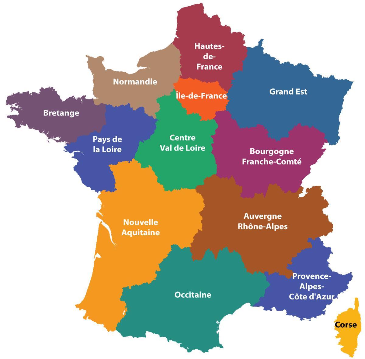
You can find on this page the France region map to print and to download in PDF. The France political map presents states, regions, provinces and surrounding areas of France in Europe.

The France regions map shows surrounding areas and provinces of France. This administrative map of France will allow you to know regions of France in Europe. The France regions map is downloadable in PDF, printable and free.
All the regions of France are or include popular tourist destinations, but there are considerable differences in culture, character and climate, from one region to another. Since 2016, Metropolitan France has been divided administratively into 13 regions as you can see in France regions map; until the end of 2015, there were 22 regions. The reduction has been obtained by merging certain regions together, as can be seen on the map above. Some of the new super-regions combine the names of the old regions, others like Occitanie or Grand Est are new.
Regions are the top tier territorial units of France. There are 13 regions in metropolitan France as its shown in France regions map, i.e. continental France plus the island of Corsica. There are also five overseas regions. Merged regions are linked by colour in the map at the top of the page. For example Midi Pyrenees and Languedoc Roussillon are now combined in a new region called Occitanie.
Many of today French regions correspond largely to the provinces of pre-revolutionary France as its mentioned in France regions map, and share the same name. Others are modern creations including areas from different historic provinces. ach region has its regional council, whose members are elected by universal suffrage. The council is presided over by a regional president, and has a full local administration to go with it. Regions have extensive powers in the fields of transport, infrastructure, economic development, tourism and education (provision of lycées), and since these powers were devolved to them from 1981 onwards regions have often worked hard over the years to develop a regional identity.

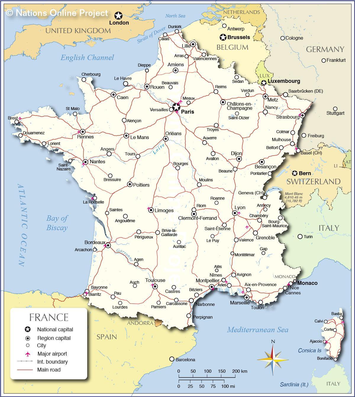
The France political map shows regions and provinces of France. This administrative map of France will allow you to show regions, administrative borders and cities of France in Europe. The France political map is downloadable in PDF, printable and free.
France is a republic; the institutions of governance of France are defined by the Constitution, more specifically by the current constitution, being that of the Fifth Republic. The Constitution has been modified several times since the start of the Fifth Republic, most recently in July 2008, when the French "Congress" (A joint convention of the two chambers of Parliament as you can see in France political map) approved - by 1 vote over the 60% majority required - constitutional changes proposed by President Sarkozy.
Since the elections in the spring of 2017, France has been governed from the centre by a brand new party called "Les Républicains en Marche" (LREM) only founded in 2016. The main political parties as its shown in France political map are: On the far right: Le rassemblement national formerly the Front National, a far-right political party originally formed by Jean-Marie Le Pen, and now in the hands of his daughter Marine. On the right: Les Républicains formerly the Popular Union Movement (UMP - Union pour un Mouvement Populaire), Centre right: the New Centre (Nouveau Centre), and the Union of Democrats and Independents (launched in 2012) l'Union des démocrates et indépendants, Centre : The Democratic Movement (Mouvement Démocratique, MoDem) . the Modem is allied to LREM, founded by Emmanuel Macron. On the left: the Socialist party (Parti Socialiste, PS) . The Radical left (les Radicaux de gauche - a centre left group).
The french goverment is appointed by the President of the Republic (Head of State as its mentioned in France political map), the Prime Minister is the Head of Government. He "directs the actions of the Government" (article 21 of the Constitution) and in principle sets out the essential political guidelines which, except in the case of cohabitation, are those of the President of the Republic.

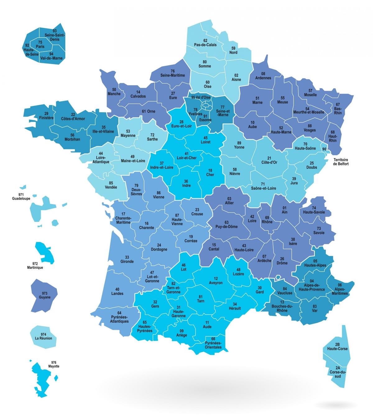
The France states map shows all departments and regions of France. States map of France will allow you to know areas and cities of France in France. The France states map is downloadable in PDF, printable and free.
The department is the second level of administrative divisions on the map of France. This division into states is between the region and the district ("arrondissement"). Each state belongs to a single region. (Each of four overseas region being composed of a single department). France is divided into 101 states as you can see in France states map. They are divided into 343 districts ("arrondissements"), 4 058 townships ("cantons") and 36 699 Towns ("communes"). Each state has a capital city or prefecture which includes its institutions. This capital is often the largest city of the state. According to figures (in 1999), the median population of a state of continental France was 511 012 inhabitants.
France is divided into 101 states as its mentioned in France states map: 96 states in mainland France, numbered 1 through 95 plus Corsica: 2A and 2B replacing the number 20. 5 overseas states (which are also regions) : Guadeloupe (971), Martinique (972), Guyana (973), Reunion (974) and Mayotte (976).
Responsibilities of the state are: social action, the restructuring of rural land, construction, maintenance, college, school transport as its mentioned in France states map. The removal of one or more local levels is being debated in France for several years and especially the option to remove maps department level. For now, the Balladur committee dealing with this reform did not adopt this proposal, so there is currently no change at the departmental level.