
: failed to open stream: Invalid argument in <b>/home/servuzmq/minisites/siteT1/common/template/carteV2.php</b> on line <b>139</b><br />
)
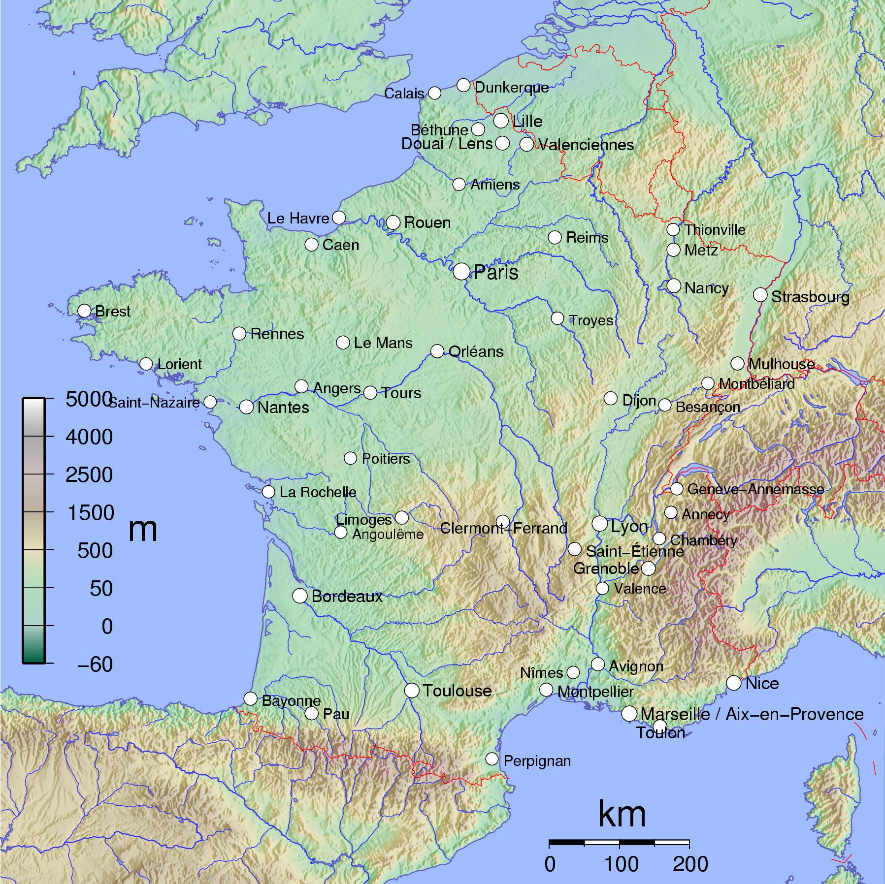
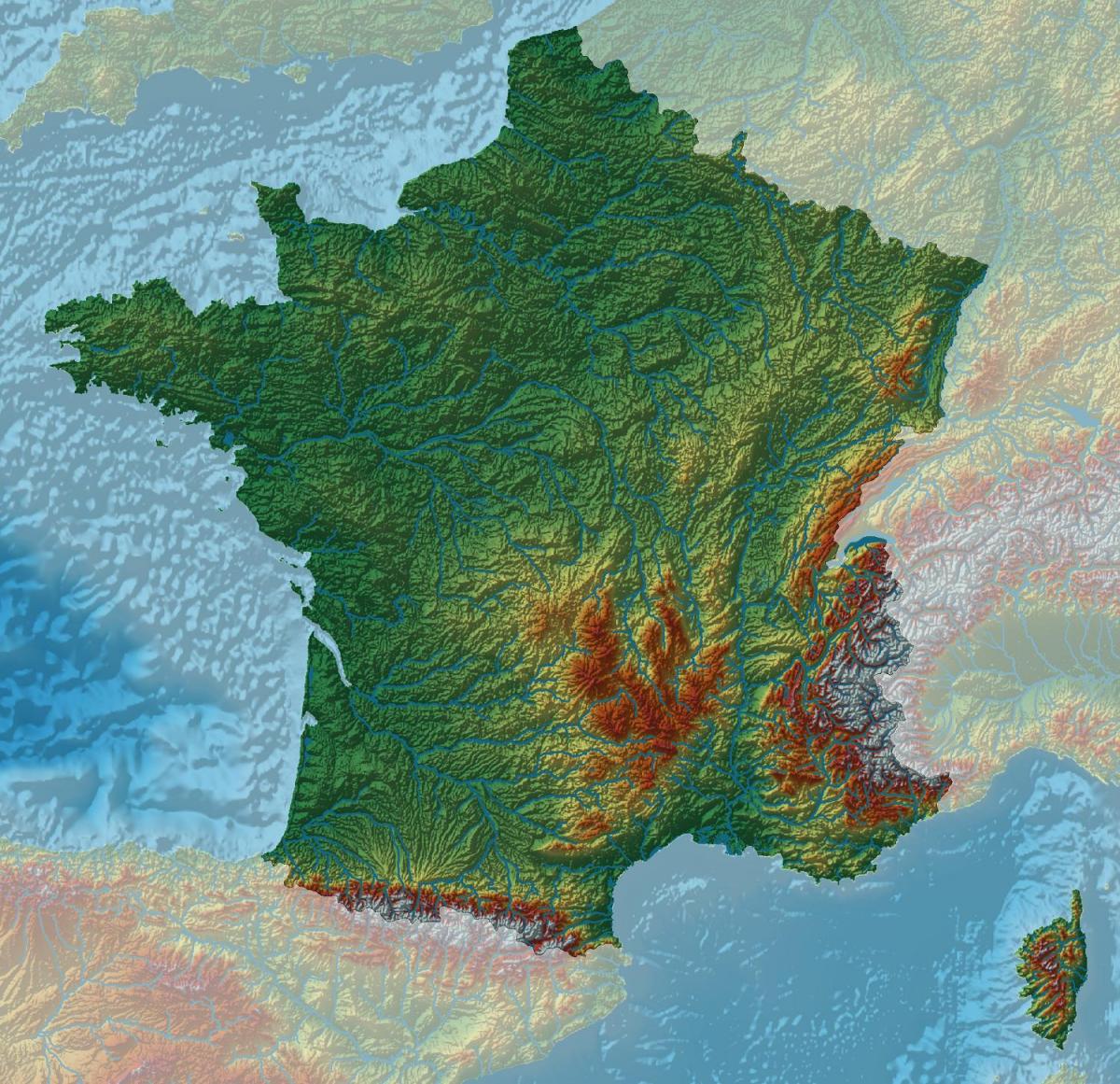
You can find on this page the France geographical map to print and to download in PDF. The France geographic map presents the topography, elevation, rivers, mountains, climate and physical features of France in Europe.
The France physical map shows landform and geography of France. This geographical map of France will allow you to discover physical features of France in Europe. The France physical map is downloadable in PDF, printable and free.
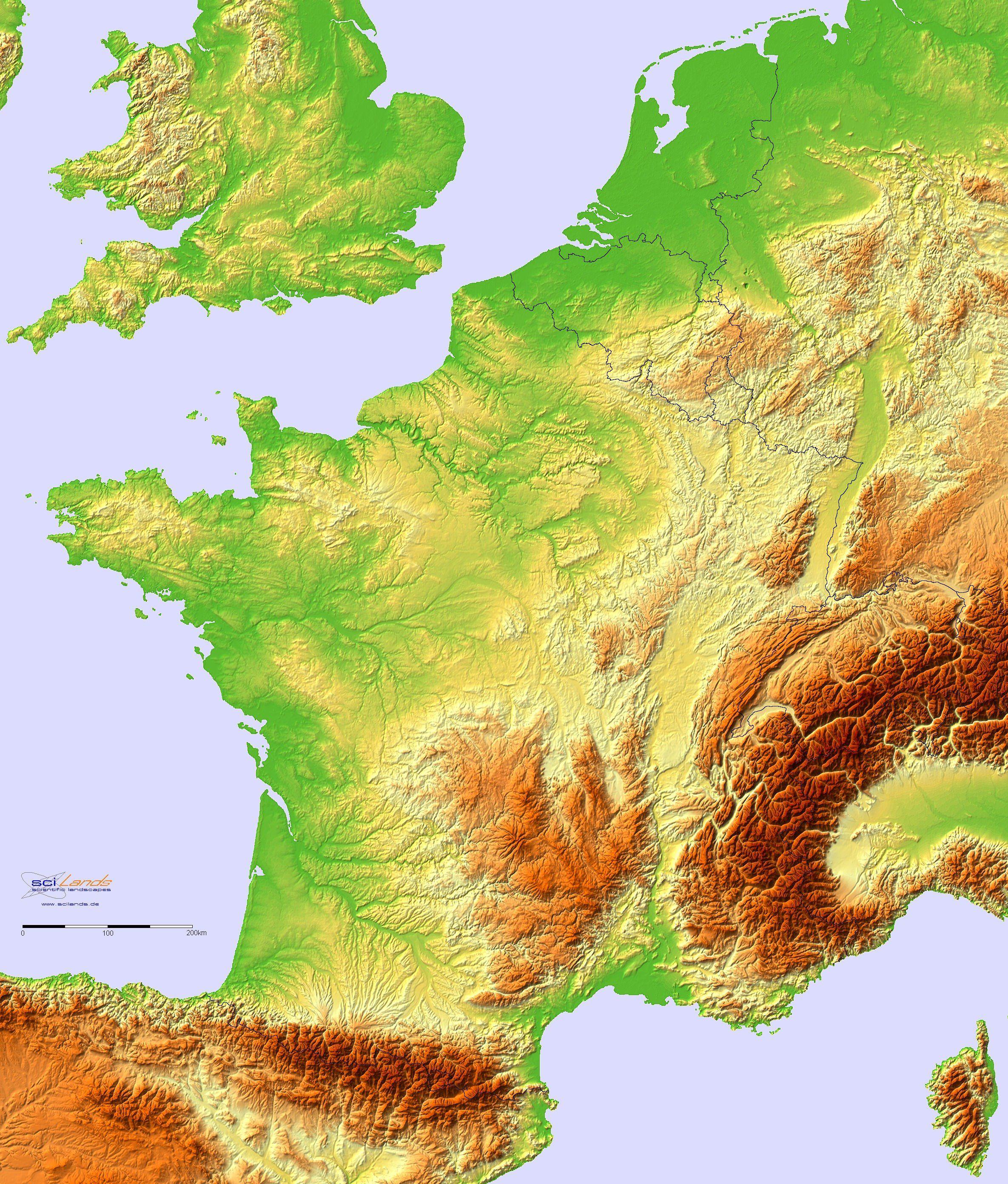
The French physical landscape, for the most part, is composed of relatively low-lying plains, plateaus, and older mountain blocks, or massifs. This pattern clearly predominates over that of the younger, high ranges, such as the Alps and the Pyrenees as its mentioned in France physical map. The diversity of the land is typical of Continental Europe.
France has ample land area to provide habitat for a wide variety of plants and animals. More than 25 percent of its physical territory is covered with forest, and another 50 percent is countryside or farmland as you can see in France physical map. Lowland forests are home to deer and wild boar, while the woodlands of the Alps and Pyrenees provide refuge for rare chamois antelope, ibex, brown bears, and alpine hares, among many other species. The Mediterranean coastline is a stopover of millions of migrating African birds, including flamingos, vultures, egrets, and bee-eaters.
The physical structure of France is dominated by a group of ancient mountains in the shape of a gigantic V, the sides of which form the two branches of Hercynian folding that took place between 345 and 225 million years ago as its shown in France physical map. The eastern branch comprises the Ardennes, the Vosges, and the eastern part of the Massif Central, while the Hercynian massifs to the west comprise the western part of the Massif Central and the Massif Armoricain.
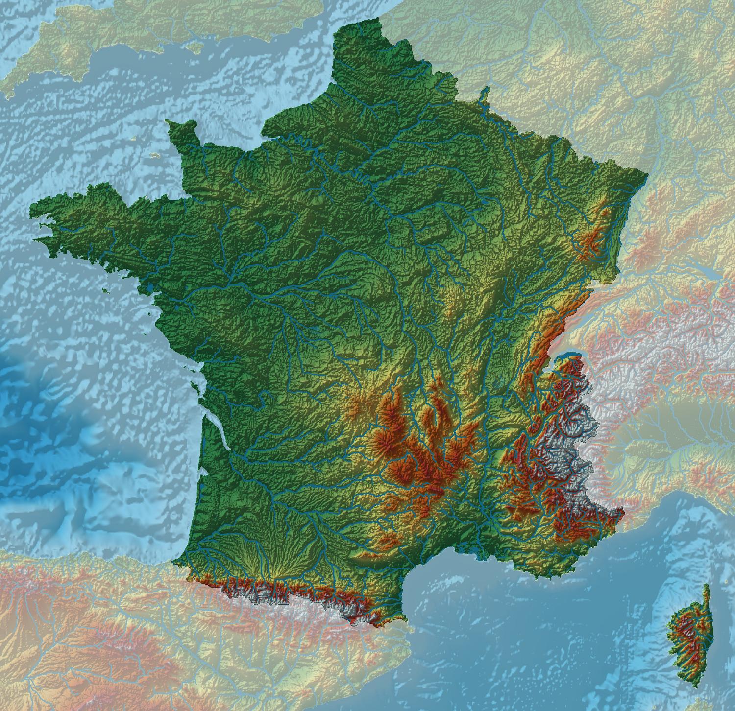
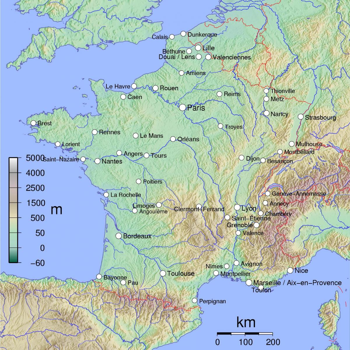
France topographic map shows the physical features of France. This topographical map of France will allow you to discover landforms and geographical of France in Europe. The France topographic map is downloadable in PDF, printable and free.
Metropolitan France has a varied topography that consists of flat plains and/or low rolling hills in the north and west as its mentioned in France topographic map, while the rest of the country is mountainous with the Pyrenees in the south and the Alps in the east. The highest point in France is Mont Blanc at 15,771 feet (4,807 m).
The upper central part of France scene is dominated by the Paris Basin as you can see in France topographic map, which consists of a layered sequence of sedimentary rocks. Fertile soils over much of the area make good agricultural land. The Normandie coast to the upper left is characterized by high, chalk cliffs, while the Brittany coast (the topographic peninsula to the left) is highly indented where deep valleys were drowned by the sea, and the Biscay coast to the southwest is marked by flat, sandy beaches.
To the south, the Pyrenees form a natural border between France and Spain, and the south-central part of the coutry is dominated by the ancient Massif Central as you can see in France topographic map. Subject to volcanism that has only subsided in the last 10,000 years, these central topographic mountains are separated from the Alps by the north-south trending Rhone River Basin.
The France elevation map shows the different altitudes of France. This altitude map of France will allow you to know where are the highest and lowest regions of France in Europe. The France elevation map is downloadable in PDF, printable and free.
France topographically is one of the most varied countries of Europe, with elevations ranging from sea level to the highest peak of the continent. The Alpine, Pyrenean and Jura mountains are much younger and have less eroded forms. At 4,810.45 metres (15,782 ft) above sea level, Mont Blanc, located in the Alps on the French and Italian border, is the highest point in Western Europe as its shown in France elevation map. Although 60% of municipalities are classified as having seismic risks, these risks remain moderate.
Mont Blanc or Monte Bianco (French and Italian, respectively, meaning "Mount White") is the highest mountain in the Alps, Western Europe and the European Union. It rises 4,810 m (15,781 elevation ft) above sea level and is ranked 11th in the world in topographic prominence. It is also sometimes known as "La Dame Blanche" (French, "the white lady"). The mountain lies between the regions of Aosta Valley, Italy, and Haute-Savoie, France as its mentioned in France elevation map.
Elevation data used in this France elevation map were acquired by the Shuttle Radar Topography Mission aboard the Space Shuttle Endeavour, launched on Feb. 11, 2000. SRTM used the same radar instrument that comprised the Spaceborne Imaging Radar-C/X-Band Synthetic Aperture Radar (SIR-C/X-SAR) that flew twice on the Space Shuttle Endeavour in 1994. SRTM was designed to collect 3-D measurements of the Earth surface.
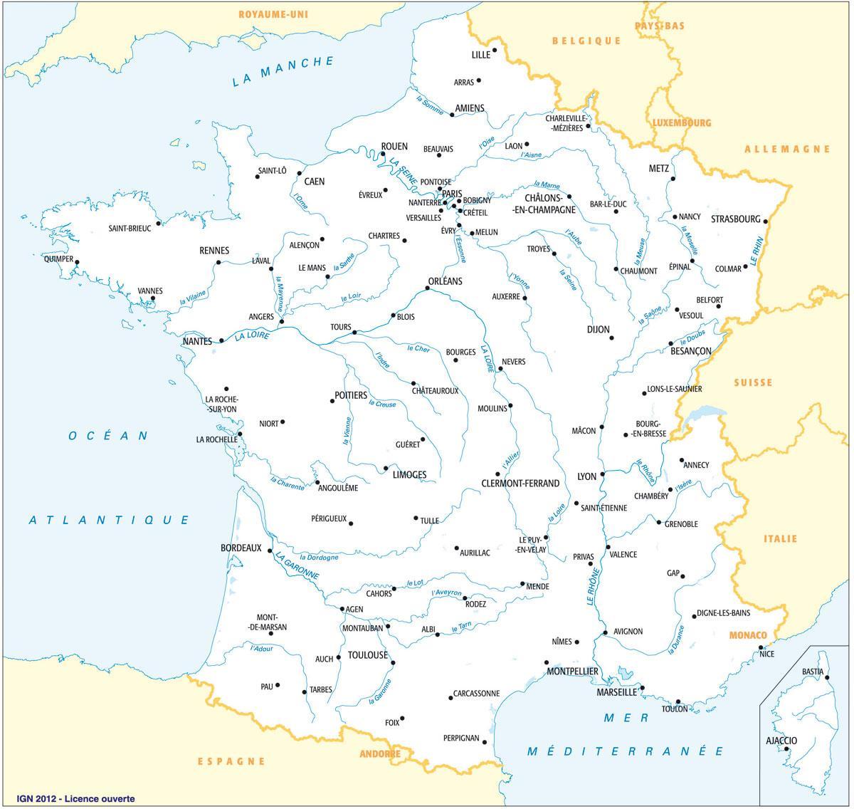
The rivers in France map shows the principal rivers with their names of France. The rivers map of France will allow you to find the main rivers which flow in and through France in Europe. The France rivers map is downloadable in PDF, printable and free.
The river systems of France are determined by a major divide in the far eastern part of the country, running from the southern end of the Vosges down the eastern and southeastern edge of the Massif Central to the Noire Mountains, the southwestern promontory of the massif as its mentioned in France rivers map. This divide is broken by occasional cols (depressions) and lowland corridors, notably the Langres Plateau, across the Jurassic outer rim of the Paris Basin.
Along the major divide in the far eastern part of the country originate most of the rivers of the larger, western part of the country, including the Seine and the Loire. Other major rivers include the Garonne, originating in the Pyrenees, and the Rhône and the Rhine, originating in the Alps as you can see in France rivers map. North of the Artois ridge, a number of small rivers flow into the Escaut (Flemish and Dutch: Schelde) to reach its North Sea estuary through Belgium.
The main river of the Paris Basin as you can see in France rivers map, the Seine, 485 miles (780 km) in length,is joined upstream on the left bank by its tributary the Yonne, on the right bank south of Paris by the Marne, and north of the city by the Oise. The Loire, the longest French river, flows for 634 miles (1,020 km) and drains the widest area (45,000 square miles [117,000 square km]). The Garonne, in the southwest, flows through the centre of the Aquitaine Basin. It is the shortest of the main French rivers, with a length of 357 miles (575 km), and it drains only 21,600 square miles (56,000 square km). The Rhône is the great river of the southeast. Rising in the Alps, it passes through Lake Geneva (Lac Léman) to enter France, which has 324 miles (521 km) of its total length of 505 miles (813 km). The Rhine forms the eastern boundary of France for some 118 miles (190 km).
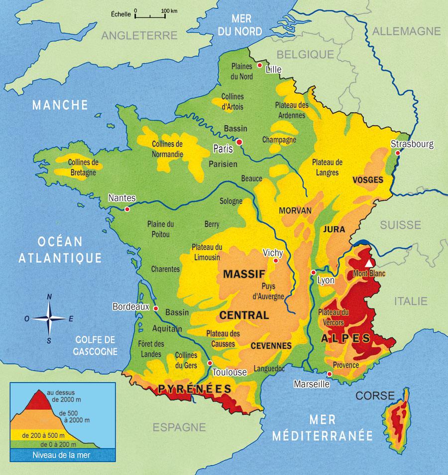
The mountains in France map shows the principal mountains with their names in France. The mountains map of France will allow you to find the main mountains ranges and highest mountains of France in Europe. The France mountains map is downloadable in PDF, printable and free.
In the high mountains and especially in the Alps, there is the contrast between the adrets, the sunny and cultivated valley slopes, and the ubacs, the cold and humid slopes covered with forests as you can see in France mountains map. The variety of vegetation on the slopes of the mountains is remarkable. Cultivated fields and grasslands are found in the depths of the valleys, followed in ascending order by orchards on the first sunny embankments, then forests, Alpine pastures, bare rocks, and, finally, permanent snow.
The Pyrenees, whose foothills shelter the picturesque Basque countryside, constitute the most ancient of the more recently formed mountains in France as its shown in France mountains map. They stretch for more than 280 miles (450 km), making a natural barrier between France and Spain. The Alpine earth movements produced a great upswelling along the line of the present upper Rhine, leaving the Vosges with steep eastern slopes that descend to a rift valley containing the plains of Alsace and Baden; on the west the upland descends rather gently into the scarplands of Lorraine.
The French Alps are only a part of the great chain that extends across Europe, but they include its highest point, Mont Blanc (15,771 feet [4,807 metres]). These majestic mountains were formed in a series of foldings during Paleogene and Neogene times as its shown in France mountains map. The vast plateau of the Massif Central covers about 33,000 square miles (86,000 square km), or some one-sixth of the area of the country. The Jura Mountains, extending into Switzerland, are composed of folded limestone. The northeastern part of the Jura, which has the most pronounced folding, is in Switzerland.
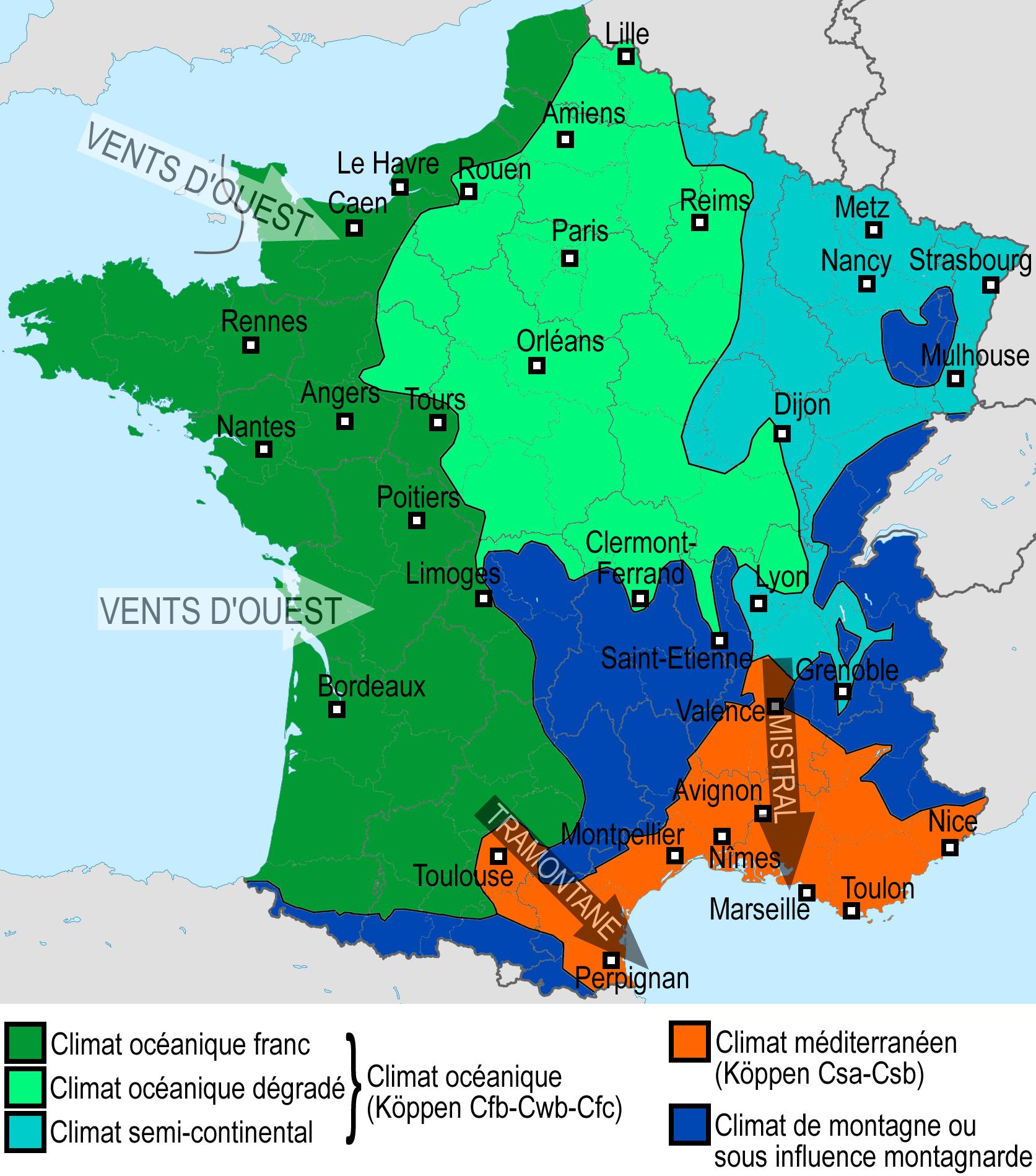
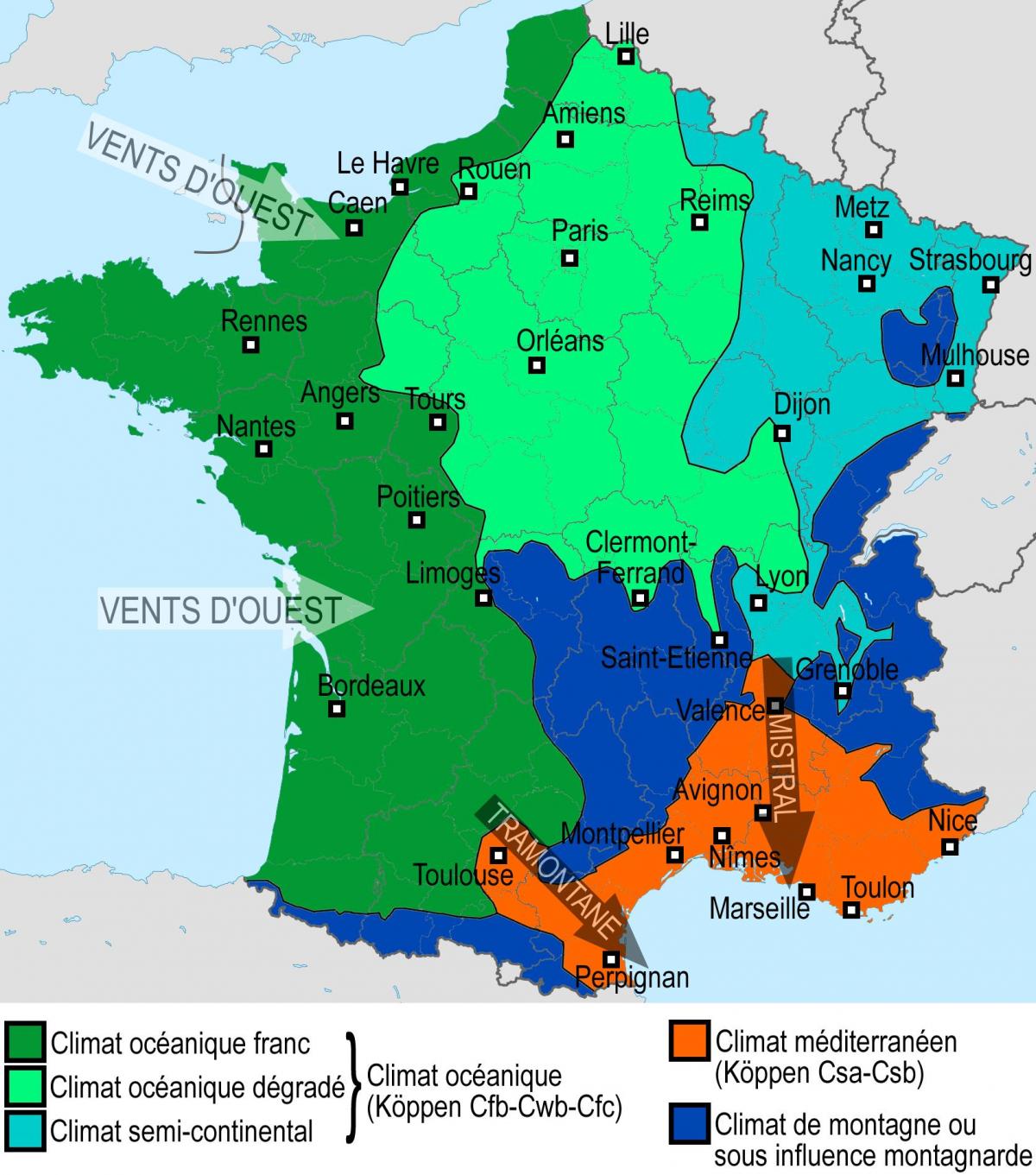
The France climate map shows average temperature and climate zones of France. This climate map of France will allow you to know weather, average precipitation, average sunshine and different climates of France in Europe. The France climate map is downloadable in PDF, printable and free.
The climate of France is generally favourable to cultivation. Most of France lies in the southern part of the temperate zone as its mentioned in France climate map, although the subtropical zone encompasses its southern fringe. All of France is considered to be under the effect of oceanic influences, moderated by the North Atlantic Drift on the west and the Mediterranean Sea on the south.
Average annual temperatures decline to the north, with Nice on the Côte d’Azure at 59 °F (15 °C) and Lille on the northern border at 50 °F (10 °C) as you can see in France climate map. Rainfall is brought mainly by westerly winds from the Atlantic and is characterized by cyclonic depressions. Annual precipitation is more than 50 inches (1,270 mm) at higher elevations in western and northwestern France, in the western Pyrenees, in the Massif Central, and in the Alps and the Jura.
In winter eastern France especially may come under the influence of the continental high-pressure system, which brings extremely cold conditions and temperature inversions over the cities, during which cold air is trapped below warmer air, with consequent fogs and urban pollution. The climate of France, then, can be discussed according to three major climatic zones—oceanic, continental, and Mediterranean, with some variation in the Aquitaine Basin and in the mountains as its shown in France climate map.
